
Being the highest mountain in Wales and the highest in the UK south of the Scottish Highlands, Yr Wyddfa, also known as Snowdon, was near the top of my list of hikes I wanted to complete once I moved to the UK. With a little time to spare before starting a new job, I spent nearly a week road tripping around North Wales. With my sights set on conquering Yr Wyddfa, anything else was a bonus. Welsh weather being as fickle as one would expect, I was lucky to have a few days up my sleeve to delay my climb and even ended up doing it twice in two days!
Contents
- History
- Before You Go… (Safety, Tips and Tricks)
- In My Backpack…
- Routes
- Helpful Resources
- Summary of Key Points
- Sources
History
Snowdon, or Yr Wyddfa as it is known in Welsh, is the busiest mountain in Wales, with over 600,000 people reaching the highest summit in Wales at 1,085m each year. It therefore gets very busy in the warmer months between those hiking up the various routes and those who catch the train to the summit (yes, there is a train!).
Yr Wyddfa, pronounced “Uhr With Va,” is said to be the tomb of Rhita Gawr, a fearsome giant who wore a cloak made of men’s beards and was decapitated after challenging King Arthur to a battle. The cairn at the summit marks the final resting place of his head, so the name “Yr Wyddfa” translates to “tomb” or “cairn.” Located within Eryri/Snowdonia National Park, over half the population living here speak Welsh and there is a wealth of history and geology, as well as the stunning views that most people travel for, if you are lucky enough for the clouds to part!
The geology of Yr Wyddfa has been shaped over many millions of years by volcanoes, tectonic movements and glaciers. Rocks were initially laid down underwater during the Ordovician period, roughly 450 million years ago. This was accompanied by underwater volcanic activity, accounting for the mixture of volcanic and sedimentary rock. Massive land movements and erosion account for what we see today, particularly following glacier activity in the Ice Age 18,000 years ago which carved out the impressive U-shaped valleys such as Llanberis.
This area has been studied by geologists for hundreds of years, including Charles Darwin who was brought to the area by Adam Sedgwick, his Geology Professor from Cambridge University after which the Sedgwick Museum of Earth Sciences in Cambridge is named (one of my favourite museums!), and learnt many of the skills that served him so well on his famous voyage on HMS Beagle.

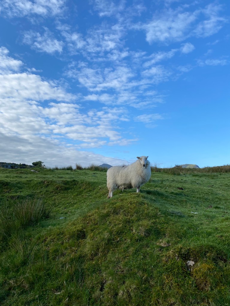
Despite the seemingly treacherous terrain, farming has occurred on these slopes for centuries. Sheep and cattle have been the main livestock in the region, with cattle predating sheep. The small, but very woolly Welsh Mountain Sheep have adapted to the extreme environment, able to pick their way sure-footed across scree and up mountainsides, dig their way through snow, cross bogs, find food when food is scarce, and find shelter for themselves in storms. They have been kept for their wool, milk and meat throughout history. Their meat is said to be of an excellent quality, winning awards and even being requested by Queen Victoria at her dinner table.
The first documented ascent of Yr Wyddfa was in 1639, where the London botanist and apothecary Thomas Johnson was guided to the top, so it had certainly been summited prior to this for there to be a guide available. The early climbers all had a scientific interest in the mountain, such as botany or geology. It wasn’t until the middle of the 18th century that the first tourists began to climb Yr Wyddfa, with the original road passing from Caernarfon to Beddgelert. The Snowdon Rangers Path was therefore the most popular initially, followed by the Rhyd Ddu path as Beddgelert grew and eventually Llanberis once that became better connected.
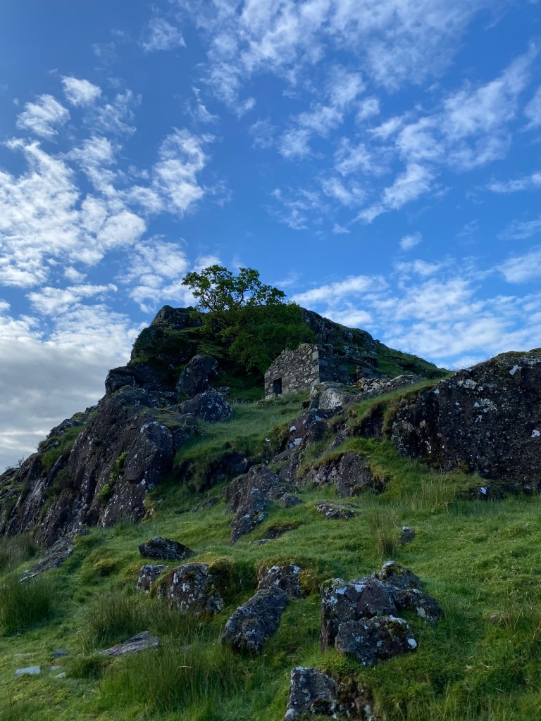
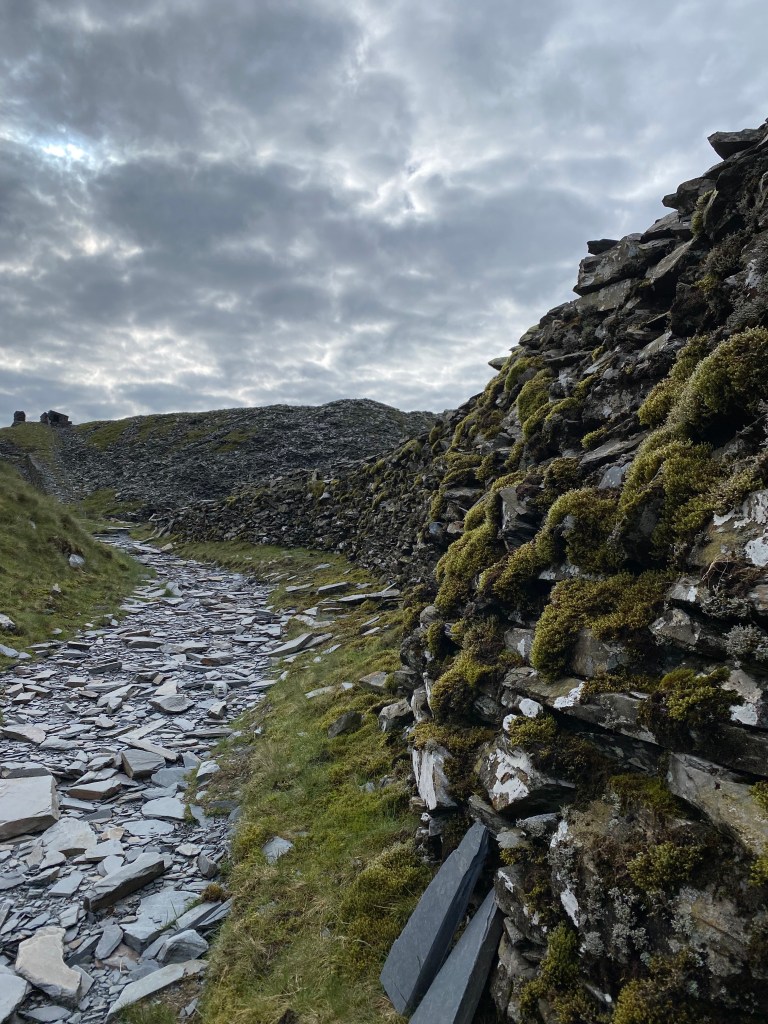
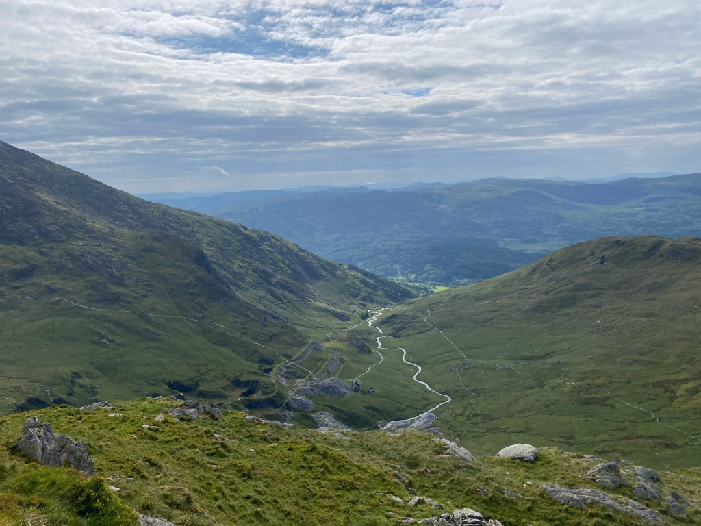
There were two working copper mines on Yr Wyddfa; one near Clogwyn Station on the Llanberis Path and the other above Glaslyn on the Pyg and Miners’ Tracks, both dating from the later 18th century. The copper ore was taken out by horse-drawn cart via the Llanberis track from Clogwyn, but was more problematic from Glaslyn at the Britannia Mine, originally having to make a climb before reaching the Snowdon Rangers track. This eventually resulted in a new track to Pen-y-Pass and the construction of the causeway across Llyn Llydaw, what is the Miners’ Track today. There were also slate mines in the area, and many miners’ houses can still be seen, most prominently around Glaslyn on the Miners’ Track.
Wooden huts were first built at the summit in the 1840s by Morris Williams, a copper miner who decided that there was more profit in selling refreshments to tourists than in mining, and later John Roberts. Their huts doubled in size throughout the 1850s and beds were added as climbing Yr Wyddfa became so popular that 200-300 people were climbing each day throughout the main season.
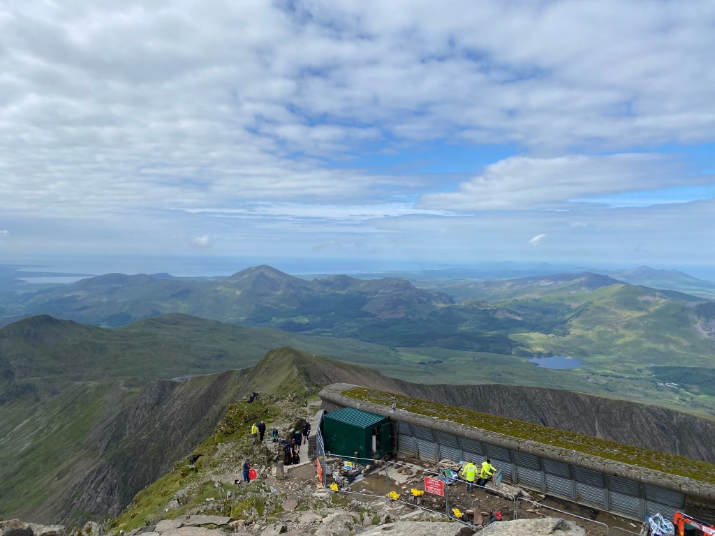
The railway to the summit was constructed between 1894-1896 and five steam locomotives were purchased from Switzerland where alpine train lines had been operating successfully for some time. Opening in 1896, this railway line still takes tourists to the summit, taking those who are unable to summit the mountain on foot to the top of the highest mountain in Wales. The wooden huts from the 1840s were falling apart and to cope with the further increase in visitors with the railway line, a new building was constructed in the 1930s, designed by Sir Clough Williams-Ellis, more famous for his design of Portmeirion Village. This combined a restaurant, overnight accommodation and the railway station. No longer withstanding the fierce mountain conditions by the 2000s, a new design by Ray Hole Architects was selected from a competition run by the Snowdonia National Park and constructed at the summit between 2006 and 2009. It was named Hafod Eryri, roughly translating from Welsh to a summer dwelling in the mountains. The pillar at the summit was rebuilt in 2001 with stairs leading up either side.
Before you go…
Before tackling this epic hike, it is essential that you assess whether this is something you can safely undertake on your own, with friends or with a guide. Mountain weather is notoriously changeable, let alone Welsh mountain weather, so it is key to check forecasts and decide whether it is safe to head off in the first place, and if going ahead, making sure you have the right gear with lots of layers and good waterproofs. It is significantly colder at the summit, so pack much warmer clothes than you need at sea level.
Navigation is another issue; paper maps and compasses are always recommended as a reliable navigation source or at least as a backup, and there are a number of apps available with offline maps. I use a combination of AllTrails and OS Maps, both of which allow you to download the map and route ahead of time so that it is available offline, something that is always needed when hiking in more remote locations such as Eryri/Snowdonia National Park. I also always take more food and water than I will need, planning for the worst case where I am stuck, alone, on the mountain in need of rescuing. As with a first aid kit, I’m always happy to have carried a little extra weight that I didn’t need as it means the worst case scenario did not eventuate!
Being the highest mountain in Wales, there is a significant amount of elevation to be gained over a not particularly long distance. This means that whatever track you take is going to be steep from the get go and being rocky, scrambly terrain, good, worn-in boots are a necessity, as is a good level of fitness.
Next is picking your route. With plenty of research and scouring AllTrails and OS Maps, I had originally settled on hiking up the Pyg track and down Miners’ Track as I was staying at YHA Pen-y-Pass, the starting and finishing point for this route, with Llanberis, the most straight-forward route, as a backup option. For my second climb, with good weather forecast all day, I tackled Yr Wyddfa via the South Ridge and Rhyd Ddu tracks.
There are six official routes to the summit of Yr Wyddfa, being the Llanberis, Pyg, Miners, Rhyd Ddu, Snowdon Ranger and Watkin Paths. While all officially described as challenging, the degree of difficulty varies with each track, as does the distance and elevation gained. Llanberis is the most straight forward, following the same route as the train line, but being the least steep it has the longest distance. Pyg and Miners’ Tracks are the shortest in terms of distance, but are steep and involve some scrambling and significantly rockier terrain than the Llanberis Path. Rhyd Ddu and Snowdon Rangers Paths are on the western side of Snowdon and are quieter routes. Rhyd Ddu doesn’t really involve scrambling, but there is an exposed ridge section so if you really struggle with heights, this is something to consider. The Snowdon Ranger Path is one of the easier routes and the views are not as good as some of the others, but it is quieter. The Watkin Path has the greatest elevation gain, starting at nearly sea level so is one of, if not the most challenging tracks with a different set of views. The South Ridge is not an official route, but can be combined with either the Rhyd Ddu or Watkin Paths for varied and interesting views, with some scrambling required.
November to March sees full winter conditions on Yr Wyddfa, so unless you are an experienced mountaineer or with a proper mountain guide, it is best to stick to the warmer months. The snow tends to linger well into spring, so snow and ice should be expected between March and May. I was hiking in late May and the trail was completely ice and snow free by this point. The summer months make for the best chance of good conditions, but with this brings the unavoidable crowds.
In my backpack…
While everyone has their own preferences, for a hike up Yr Wyddfa, or any mountain day hike in summer (definitely more layers would be required earlier or later in the season), this is typically what I would take.
- Osprey Women’s Tempest 34L Backpack – could go smaller, but this is my tried and tested favourite that I use for all my hiking, multi-day or day hikes
- Worn-in hiking boots with good grip for rocky, uneven terrain
- Light-weight merino hiking socks
- Quick-drying t-shirt
- Merino long-sleeve thermal shirt
- Light-weight hiking pants
- Woollen beanie or head band
- Gloves
- Merino buff
- Waterproof jacket
- Waterproof pants
- Waterproof backpack cover
- Fleece jacket
- Puffer jacket (not worn, but just in case!)
- Snacks and lunch for the day (although I was back down for lunch, I always take more than I will need in case of an emergency situation or I’m enjoying myself too much to come down in a hurry)
- Water
- First aid kit
- Hiking poles – not for everyone, but I like using them for the downhill on steep, rocky terrain
For a rainy day in late May with no visibility, I wore the merino long-sleeve and waterproofs the entire way up and back, along with the fleece while enjoying the summit. I also wore my woollen headband for the entire decent and a lot of the ascent, with the gloves and buff for sections. As stated earlier, it is definitely much colder at the summit, particularly on a rainy day. On the second climb in sunny weather I still wore my waterproof jacket for the entire hike for the wind, as well as the merino thermal shirt for a significant portion of the hike.
Routes
Pyg and Miners’ Tracks
Key Details:
Getting to the starting point of these tracks, Pen-y-Pass, is half the battle. I stayed at the YHA Pen-y-Pass to avoid this issue, meaning I could wake up at a reasonable hour and set off from the front door whenever I was ready. Without this luxury, on a day with good weather, let alone a weekend, you need some serious planning and an early wake up to get to the starting point in time. The reason this is such a problem is that the car park at Pen-y-Pass is very small and to better handle this issue, it operates on a prepaid basis throughout the warmer months. Even if you stay at YHA Pen-y-Pass, you would have to negotiate this as they do not have their own car park for guests.
Fortunately, there are regular buses running to this spot from Llanberis where there is a large car park that you can stay in overnight (Parking for Snowdon on Google Maps), as well as a car park in Nant Peris (Maes Parcio Car Park on Google Maps) which is a little closer. I opted for the car park in Llanberis as it was bigger and there were things I wanted to do in Llanberis when not hiking, being a bigger town. I used the app, PayByPhone Parking, so that I could top up the parking while at the YHA. Buses run to Pen-y-Pass every 30 minutes and you can pay using card once on the bus. Whichever you chose, I would definitely recommend this option rather than trying for Pen-y-Pass.
More about parking:
https://www.paybyphone.co.uk/locations/gwynedd
https://snowdonia.gov.wales/visit/snowdon/parking-for-snowdon/
https://snowdonia.gov.wales/visit/plan-your-visit/snowdon-sherpa/
Once you’ve got yourself to Pen-y-Pass, the fun begins! Taking the Pyg Track to the summit is a great way to make the route a little more challenging than the Llanberis Track as there is some scrambling involved and some of the best views, particularly of the mountain lakes if you’re lucky enough to be able to see them. Definitely only take this route if you are comfortable with scrambling as there are some steep sections towards the summit, but if you are okay with this, there is nothing overly challenging apart from the decent amount of elevation to be gained. In saying this, this route is the shortest route to the summit and also has the least amount of elevation to be gained.
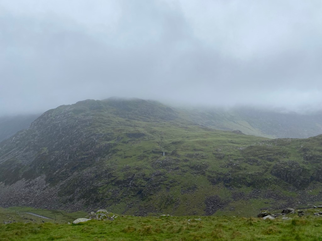
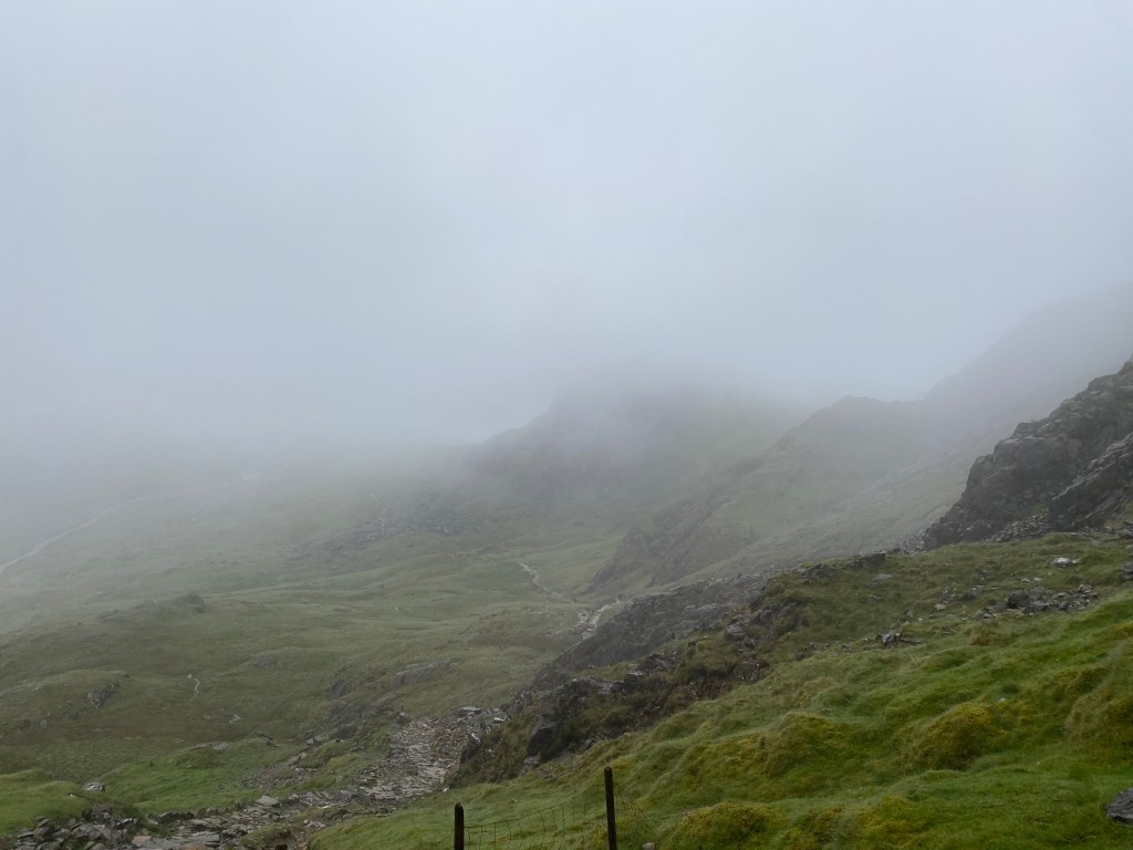
Signage along the route is mostly pretty good; however, it is quite sparse so I did find myself checking my offline map a few times for reassurance. There were only two sections involving scrambling where I did rely on the map a little more, but this was mostly due to the complete lack of visibility. Had it been a clear day, I suspect it would have been much more obvious where the trail was heading. The trail is very well-maintained and I suspect there are very few days when there are not many others hiking around you. Even on a miserable Friday I was constantly passing people.
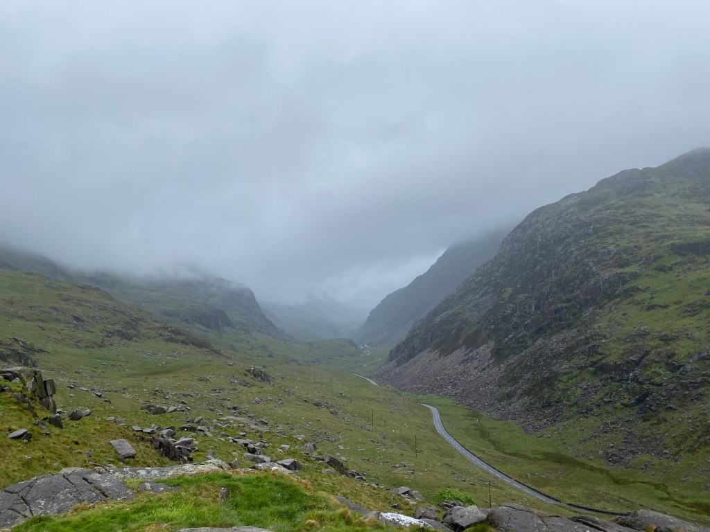
From the car park at Pen-y-Pass, take the trail to the right for the Pyg Track behind the Pen-y-Pass Warden Centre, saving the Miners’ Track on the left for the return. This is well signposted and if it’s anything like the day I climbed, everyone I saw seemed to be heading this way too. The trail is pretty much uphill from the get go, and while wide and easy to follow, it is uneven and rocky, with some deeper muddy patches along the first section. While I didn’t have much of a view of the mountain ahead, you get a great vantage over the road snaking below very quickly.
After the first kilometre or so, the trail divides into two. The trail to the right heads up Crib Goch which is a Grade 1 scramble, so be sure to remain on the Pyg track! This point is well signposted and you would have to cross a stile to head up to Crib Goch, but still make sure to pay attention.
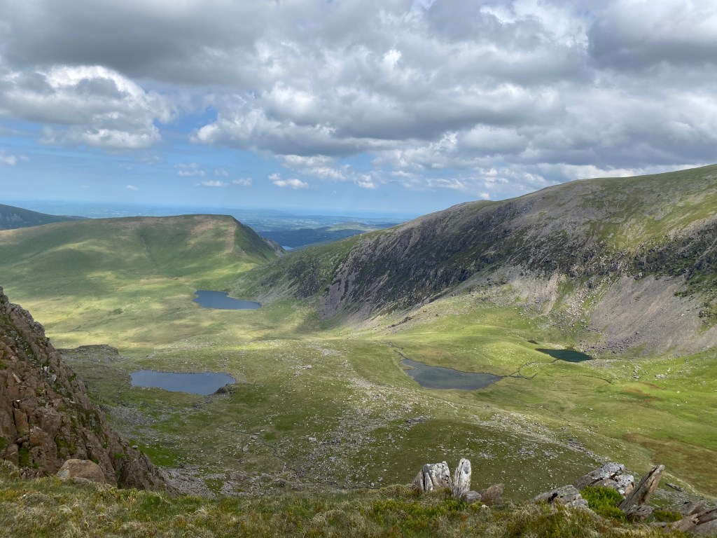
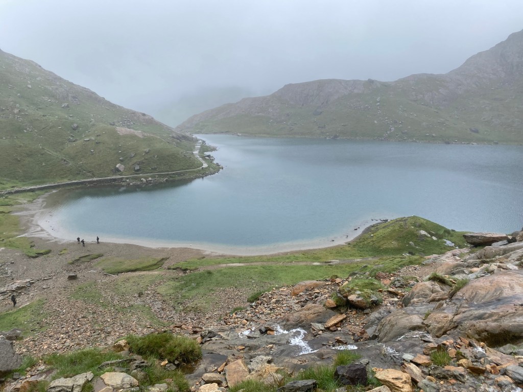
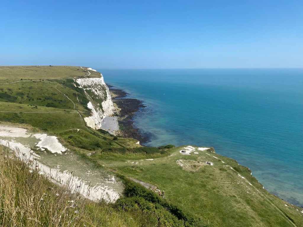
From here you are treated to views down to your left of the large mountain lake, Llyn Llydaw, which you will walk along on the return journey on the Miners’ Track, noting how much lower that route is. Crib Goch is high above to your right and you can start see the summit of Snowdon in the distance, if you are lucky enough not to be surrounded by cloud that is! There are a few rocky sections through this part of the trail which were not overly difficult.

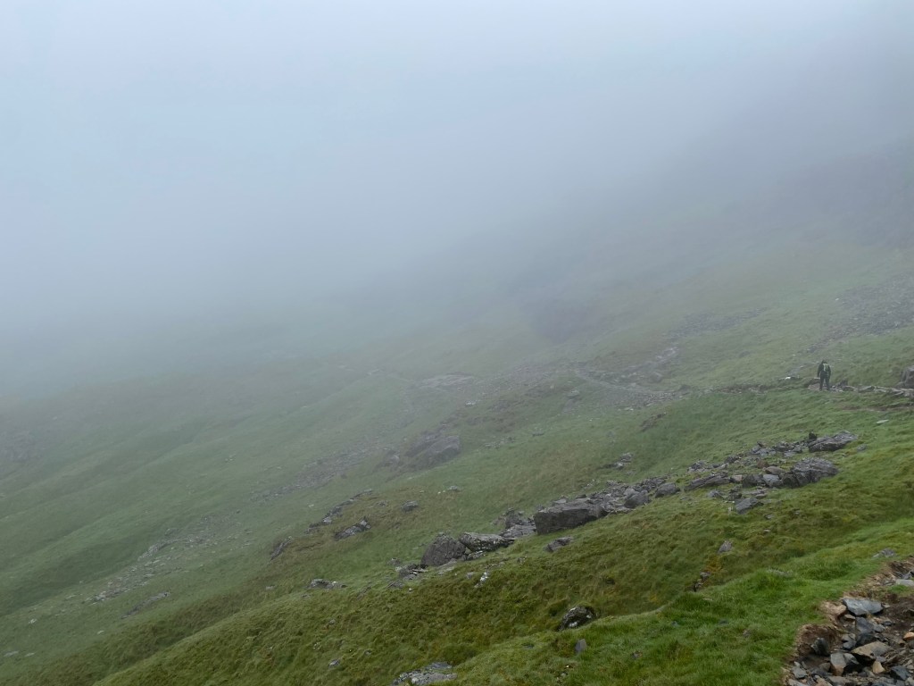
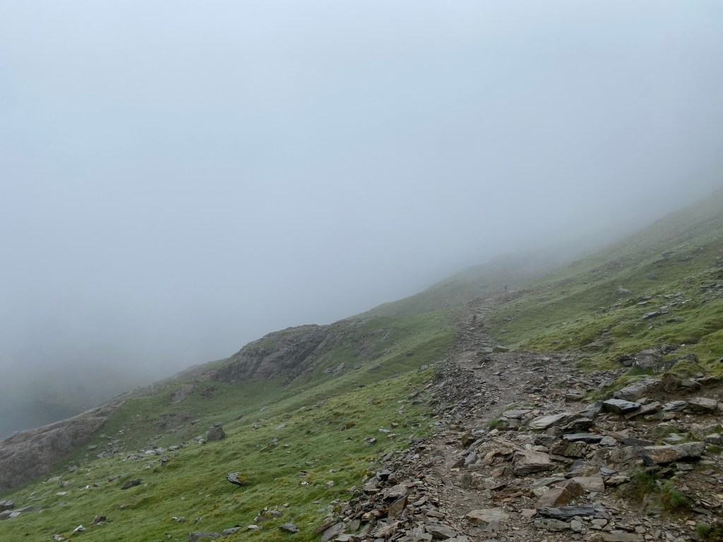
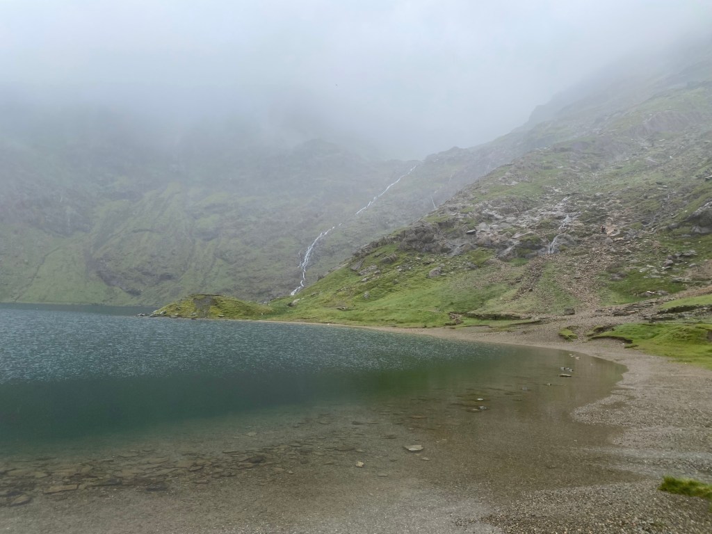
With Llyn Llydaw disappearing from view, Glaslyn, a smaller lake becomes visible to your left, soon reaching a marker at the junction of the Pyg and Miners’ Tracks. Make a mental note of this junction as you will be taking the other track for your descent. From here the trail becomes steeper, climbing up a slippery scree section (not too bad if you stick to the trail) and a couple of scrambles. I enjoyed this section, being a little more challenging when compared to the rest of the hike and you quickly gain elevation to emerge onto the wide open, gradually ascending Llanberis track, marked by a large stone, with the train line running alongside it. This final section is the combination of the Llanberis, Pyg, Miners, Crib Goch and Snowdon Rangers tracks, so it will be substantially busier. The final ascent was straightforward, eventually climbing wide, well-made steps to join the queue for the summit. On a Friday with no visibility I was able to walk straight up to the summit, but this is usually not the case!

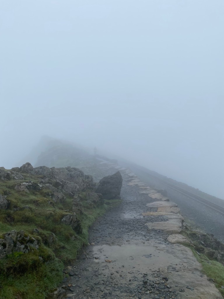
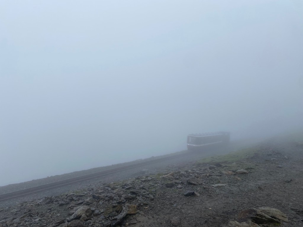
Making the most of the strange luxury of having toilets and shelter on the summit of a mountain, I escaped the elements for a while, enjoying the relative warmth of the cafe. Refueling on muesli bars, fruit and my hiking essential, Fruit Pastilles, I gave my legs a short rest at a table by the huge glass windows, which would have provided incredible views on a different day. After picking out the train riders in their dry, non-hiking clothes from the cold, bedraggled hikers, I decided I better make for the descent before I cooled down any further.
Having to don all my warm layers and still shivery, I made a hasty descent of the Llanberis Track to warm back up again. Reaching the stone marking the turn off for the Pyg and Miners’ tracks, I warmed up quickly having to negotiate ascending traffic and slippery, rock scrambles on my descent. Having carried by poles in my backpack for the entire ascent, I was extremely grateful as they definitely helped through this section and the first section of the Miners’ track, mostly to give confidence to someone with a fear of heights!
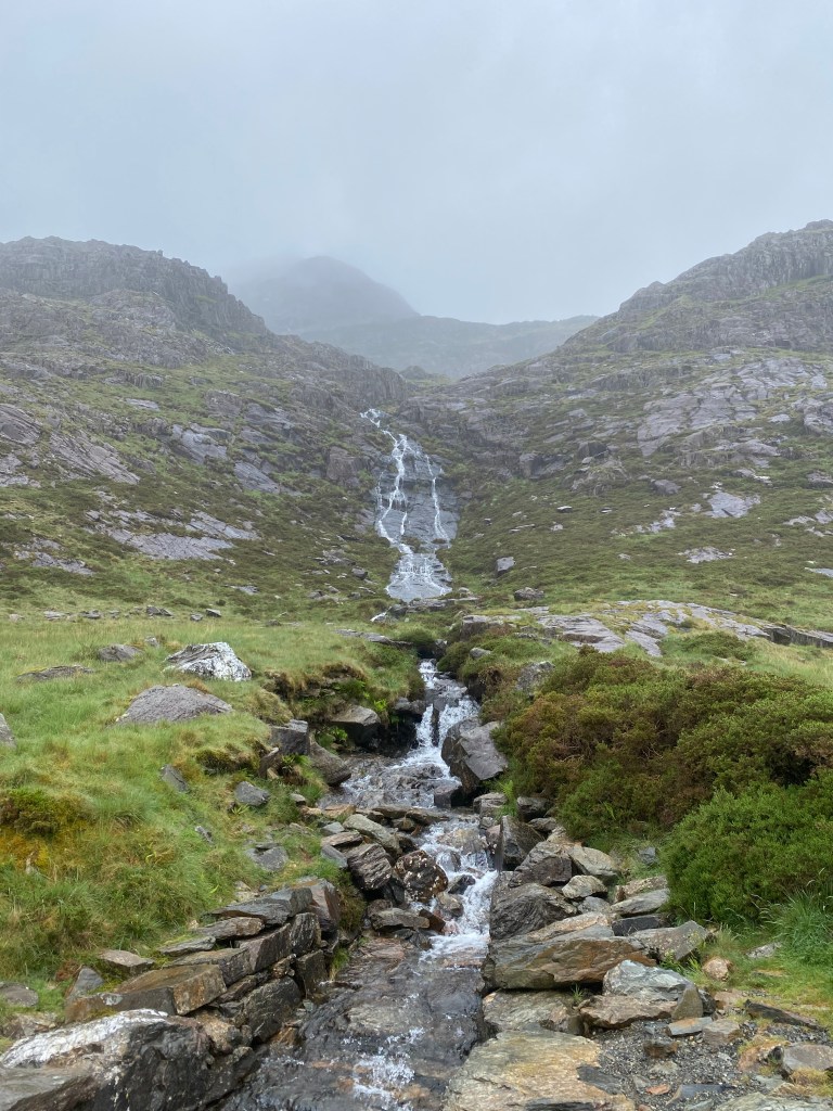
Reaching the stone marking where the Pyg track splits into two, I took to steeply descending Miners’ track while the Pyg track carries on to the left, high up above the lakes below. While not technically too difficult, I did find this section required the most concentration, as it descended very steeply through uneven, rocky terrain where great care is needed. Hiking poles definitely helped me through this section. This leads you down to the shore of Glaslyn, and in the misty shroud of cloud, with waterfalls in abundance, greenish-water and looming shadows of rock towering above, this was a truly atmospheric section to walk. I felt as though I had stepped into a world created by Tolkien, with Gollum ready to emerge from the shadows or something terrifying from the lake.
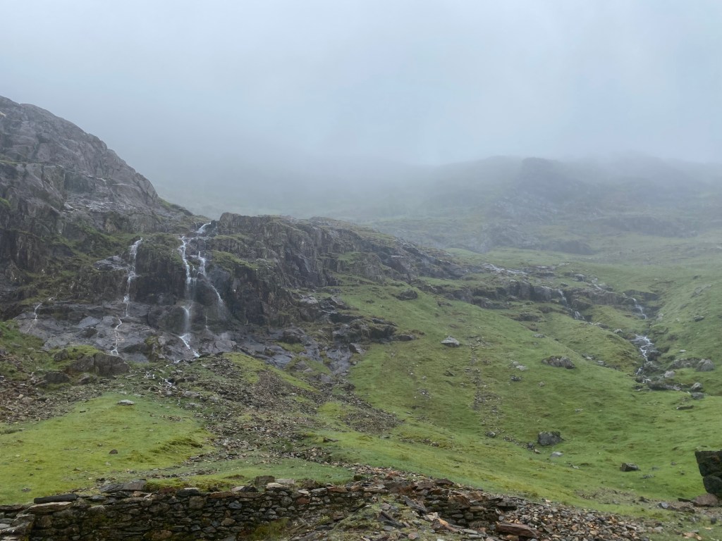
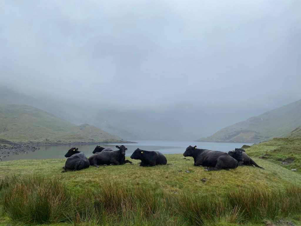
From this point onwards the Miners’ track is very straightforward, hugging the lake shore before descending more gently to skirt around Llyn Llydaw on a mostly flat track with waterfalls and the remains of copper mining huts from the Britannia Mine to your left. Heading across the lake, over the causeway constructed to avoid the use of boats in moving copper mined to the road, past cattle huddling in the mizzle, I sped onwards along the easy track humming to myself in anticipation for warmth and dryness around the corner.

Rounding the mountainside to the car park and returning to the YHA Pen-y-Pass exhilarated by my achievement, particularly in overtaking a groups of guys in the last few minutes (I do have a competitive streak it seems…), I treated myself to a delicious slice of cake and cup of tea to celebrate and complement my packed lunch. Collecting my bags and jumping on a bus back to my car in Llanberis, I spent my afternoon “relaxing;” hiring a kayak for two hours from Snowdonia Watersports, I paddled my way around this slate grey lake, surrounded by mining history.
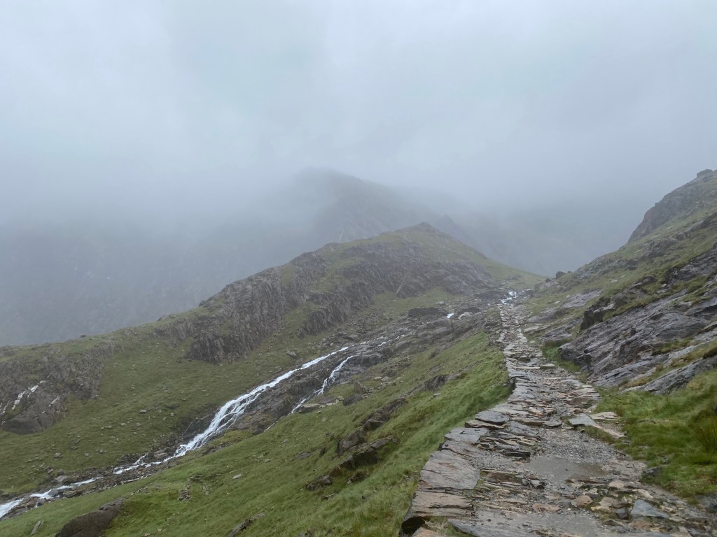
Snowdon South Ridge and Rhyd Ddu Track
Key Details:
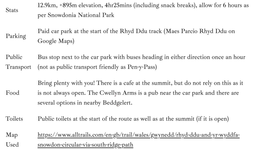
Waking up to the most beautiful blue-skied morning, I knew I had to climb Yr Wyddfa for a second time to see everything that had been shrouded by clouds the day before. Wanting something different, I settled on the Rhyd Ddu Track, pronounced “rheed-thee,” for a couple of reasons. The main reason was that being a Saturday, and one with blue skies at that, it was going to be busy and with Rhyd Ddu being one of the least walked routes up Yr Wyddfa, I figured I stood a good chance of getting a car park. Secondly, it is a small step up from the Pyg and Miners’ tracks and while I didn’t get any views on those routes, this offers a different perspective and arguably some of the best views around Yr Wyddfa, particularly if doing a loop with the South Ridge as I did.
Arriving at the car park around 7:45am there were still quite a few empty spots, but it was definitely filling up quickly. I would hazard a guess that by school holidays and peak summer I would have struggled to get a spot at this time. Already feeling lucky as it was my birthday and the sun was out, I was then handed a parking ticket that had been paid through until late that evening by someone who was leaving, so I knew it was going to be a good day.
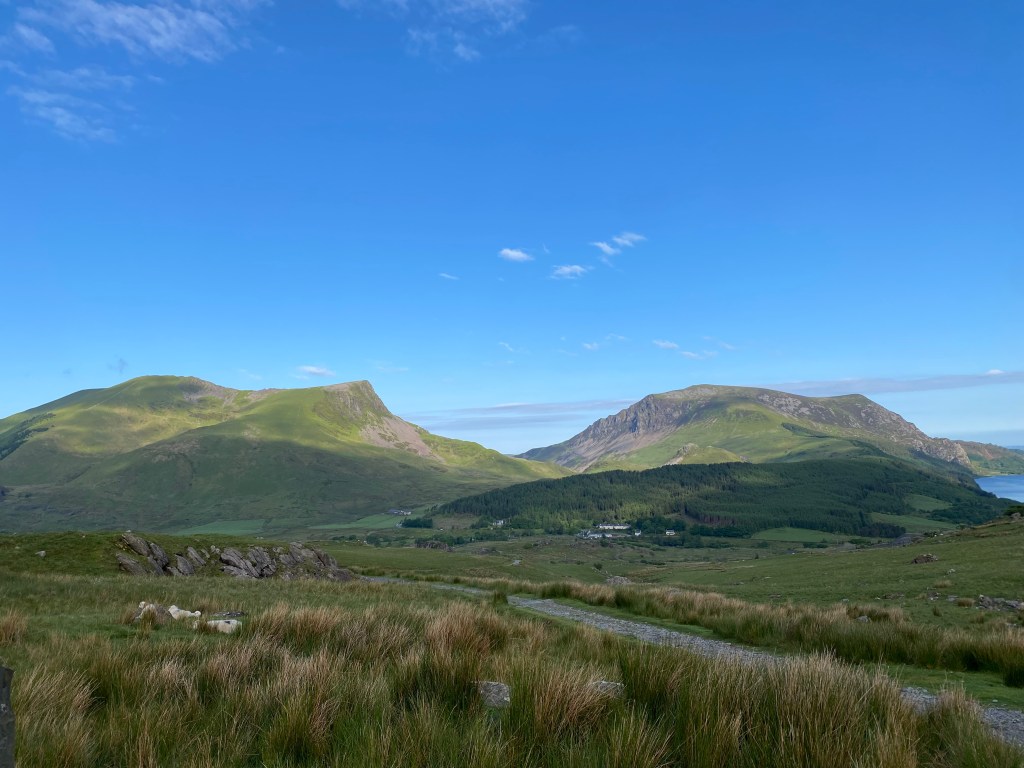
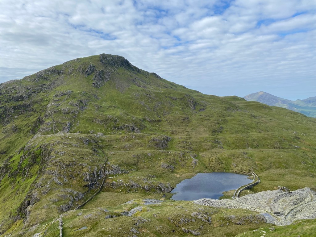
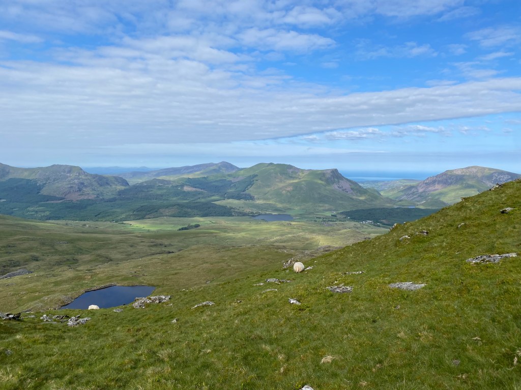
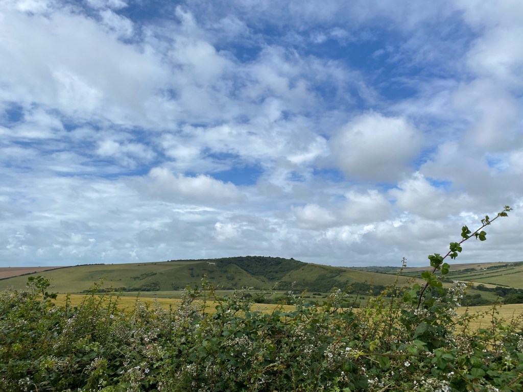
Following the Rhyd Ddu track to start, I was amazed by the sight of Yr Wyddfa directly in front of me, so imposing, particularly after being only conscious of my immediate surroundings a day prior due to the thick cloud. The views to my left of Llyn Cwellyn snuggled between mountains in the distance was also beautiful and I passed some Welsh Mountain Sheep, the wooliest sheep I have ever laid eyes on. The views behind you are also lovely, of the Nantlle Ranges, a vibrant green in the morning sunshine. Reaching a junction in the track, I headed straight ahead towards the Snowdon South Ridge, rather than the Rhyd Ddu track to the left.


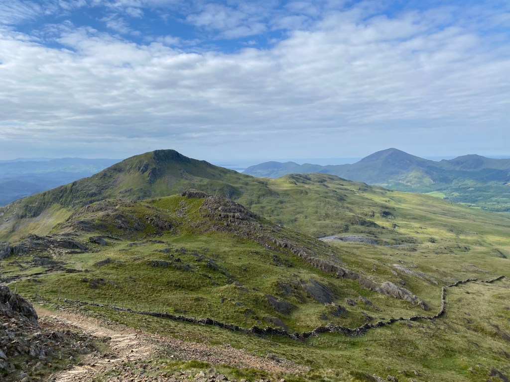
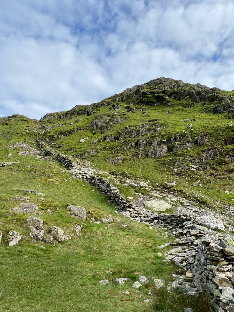
Here the track continued steadily uphill, with slate mining remains, waterfalls and the distant mountains for interest. Away from the main trail, I saw three people in total until rejoining the Rhyd Ddu track just before the summit, so I could fully enjoy the solitude and the sound of the wind. Increasingly steep but very easy to follow and easy to keep up a good pace due to being an old access path, I reached Bwlch-Cwm Llan, the col between Yr Wyddfa to the left and Yr Aran to the right in what felt like no time. Ahead is the vast cwm or cirque beneath the south face of Yr Wyddfa, the steep-sided head of a valley or mountainside formed by glacial erosion, which provided awe-inspiring views in the bracing wind.


From here the going was tougher, with some short scrambles requiring a little use of hands, always heading upwards to the summit which was beckoning, becoming more and more visible. The track was mostly easy to follow, with a steep drop to the right and a smoother, grassy drop to the left towards the Rhyd Ddu track. There was only one section that was a little more challenging, being a longer scramble up jagged rocks, but nothing a more experienced hiker couldn’t manage.
Climbing this section, while a workout for the legs, gives you a sense of just how incredible the views are to come. Regularly turning around to take in the view behind me, Yr Aran rose up with a slate grey lake and the remains of the mining past below.

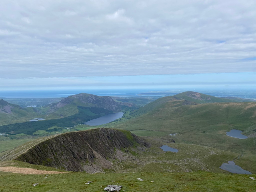
Reaching Bwlch Main just before rejoining the Rhyd Ddu track, the track suddenly becomes exposed, with drops down to Cwm Clogwyn to the left and Cwm Llan and Lliwedd to the right. For someone who is not great with heights (me…), I took a moment here to steady myself and absorb the truly spectacular scenery. With the expansive valleys to either side and the summit of Yr Wyddfa directly ahead, it is worth taking a second here to take it all in whether the heights bother you or not. On a day like I had, you can see all the way out to the west coast of Wales to your left, and the variety of blues and greens was mesmerising.
Many descriptions will tell you that a head for heights is necessary to complete this route. I can prove that it is not necessary, just the will power to put one foot in front of the other. The spectacular scenery definitely helped, as did the sheep perched along the vertiginous mountainside. I fully appreciate that this would not be the case for everyone.


With the track becoming a little busier here, merging with those who had climbed up Rhyd Ddu track and then those from the Watkin Path a little further on, the last push for the summit was up a steep scree section, overtaking as many people as I could. Passing the cafe and train station to my left, Hafod Eryri, I continued upwards to the summit. Here I joined a long queue up the final set of stairs to the summit pillar for a photo and with clear skies, it made for a very different background than the day before! It was incredible to see everything I had missed the day before, tracing out the Pyg and Miners’ tracks to the south and marvelling at what I could have been looking at the day prior. If anything, it made this ascent even more special.

Heading back to Hafod Eryri, I gobbled up my snacks, made use of the very convenient toilets, then headed back in the same direction to return via the Rhyd Ddu track. Using poles for the descent definitely helped with my fear of heights, as did my need to ensure that no one overtook me (unless they are running!). In fact, I thoroughly enjoyed Bwlch Main this time around, knowing what to expect and able to fully appreciate the views, and it was only too soon that I had to leave the ridge line behind and descend via the gently sloping Rhyd Ddu track.
Easy underfoot for the most part, you can let your feet take you onwards while enjoying the views play out in front of you, with the summit to your right and the expanse of the valley dotted with lakes in front of you. There are a few steeper sections and stretches of looser rocks, but the track is wide and easy to follow, never once having to pull out my offline map to confirm my directions. This also means it is easy to deal with the increased number of walkers, rarely having to pull over to let others pass.


Reaching the end of the rockier descent, you can fly along the track back to the train line and the car park beyond being a steady downhill on an old access path. Arriving back at the car park on an absolute high, I could have done it all over again!
Helpful Resources
https://www.metoffice.gov.uk/weather/specialist-forecasts/mountain/snowdonia
https://snowdonia.gov.wales/visit/plan-your-visit/guides/yr-wyddfa-choosing-the-right-path/
https://www.paybyphone.co.uk/locations/gwynedd
https://snowdonia.gov.wales/visit/snowdon/parking-for-snowdon/
https://snowdonia.gov.wales/visit/plan-your-visit/snowdon-sherpa/
Summary of Key Points
- Carefully assess whether this hike is for you based on the amount of elevation gain (it is steep from beginning to end whichever route you take)
- Choose your route wisely – they are all different based on starting points, elevation gain, distance covered, scrambling involved, parking and public transport links. The Snowdonia offical website provides a good comparison as well as helpful safety advice.
- If beginning at Pen-y-Pass working out how you will arrive is critical as parking is extremely limited. I would strongly recommend parking at Llanberis or Nant Peris and then catching the regular buses to Pen-y-Pass.
- Check the weather before you go (don’t go if it’s set to be dangerous) and pack appropriately, with lots of layers and waterproofs even if it is predicted to be a sunny day. Better to carry a little extra weight than regret that extra jumper or waterproof pants!
- Ensure you download all maps prior to arriving at the car parks as there was no reception and only limited signal while heading up the mountain.
- Always take a power bank if you are planning on using offline maps as your main source of navigation.
- Tell someone where you are going, what route you are taking and what time they should expected to have heard from you by. Run through what they should do if they haven’t heard from you, eg. call your accommodation, contact mountain rescue.
- Pack plenty of food and water even though there is a cafe at the summit as this is not always open, particularly if the weather is bad.
- Have fun!
Sources
https://snowdoninfo.com/history-of-snowdon/
https://snowdonrailway.co.uk/discover/history-2/
https://snowdonia.gov.wales/discover/landscapes-and-wildlife/geology/
https://snowdonia.gov.wales/discover/culture-language-and-community/the-people-of-snowdonia/charles-darwin/
https://snowdonia.gov.wales/visit/plan-your-visit/guides/yr-wyddfa-how-to-pronounce-snowdon-welsh-name/


Leave a reply to jameskeneally Cancel reply